01
An apartment complex where the Town plans rural homes
Greenfield's Comprehensive Plan calls for "a primarily rural, residential community" and says that even in the town's densest area, one-acre lots will typically be the smallest. This plan puts 184 apartments in 37 buildings on a single parcel.
The facts & sources
- The Town's vision: "a primarily rural, residential community… comprised primarily of large tracts of land providing privacy and quiet," with "breathtaking views of mountains and sky." Comprehensive Plan, p. 53
- The applicant cites the same plan's statement that the densest development is expected in the south of town. That same passage says density there "is not likely to be as dense as… Saratoga Springs" and that "one acre lots will typically be the smallest lots."
- 184 units on 42.7 acres works out to about 4.3 homes per acre across the whole parcel. Because the buildings sit on about 8.5 acres, the built area is far denser than that.
- Residents surveyed for the plan named "the rural location and attractive, peaceful lifestyle" as the town's main strengths. p. 47
- From 6, 11 and 18 Bloomfield Road, the buildings would be plainly visible. See the photos
02
About 1,200 more car trips every day
Bloomfield Road carries about 1,555 vehicles a day today. With 184 apartments and 2–2.5 cars each, standard trip rates add roughly 1,100–1,400 trips a day, close to doubling the road's traffic. Those trips spread onto Denton, Daniels and Locust Grove Roads, and event traffic comes on top.
The facts & sources
- Today: about 1,555 vehicles a day on Bloomfield Road, measured by the applicant's own traffic counter in June 2026. 85% of drivers go 48–49 mph or slower. Traffic study, p. 2
- The math: 184 units × 2–2.5 cars = 370–460 more cars. At 3 trips per car per day, that is 1,100–1,380 trips. The industry standard (ITE) rate for apartments, about 6.7 trips per unit per day, gives about 1,240.
- Events: the applicant's study modeled a "worst-case special event" with 350 guests.
- Safety: the stretch between Daniels and Denton Roads had 4 crashes in five years, 3 of them with injuries. There are no sidewalks or crosswalks.
- The applicant reports peak-hour figures only: 69 trips in the morning and 102 in the evening. Only one page of the 8-page study is in the public record.
03
Taxpayers just paid to rebuild these roads
In 2026 Greenfield rebuilt and repaved Denton and Bloomfield Roads, including ditching, drainage and new storm drains near Seward Street and Denton Road. The developer now plans water and sewer lines along those same roads, and has offered no bond or guarantee that they'll be restored to new rather than patched.
The facts & sources
- Denton and Bloomfield Roads are two of the seven roads (5.94 miles) in the Town's 2026 program of "tree work… ditching and infrastructure repair" and then repaving.
- The Town's 2026 capital paving line (matched by state CHIPS aid) is $378,317. Counting crew labor and drainage work, the program costs an estimated $380,000 to $1 million or more.
- The applicant's sewer line runs "over one mile along Denton and up Bloomfield Road," and its water main runs 6,800 feet. Application
- The developer's own engineer budgets just $40,800 for "restorations" along the whole 6,800-foot water route, about $6 per foot. Water agreement, cost estimate
- The PUD law leaves the size of any performance bond to the Planning Board. We're asking for a bond that guarantees full-width repaving.
04
Your homeowners insurance could cost more
Greenfield homeowners benefit from the Fire District's strong ISO rating of 4/9, which insurers use to set premiums. The applicant hasn't engineered the fire protection for 37 buildings, and hasn't studied the added load on our volunteer fire and EMS crews.
The facts & sources
- The ISO "Public Protection Classification" rates fire protection from 1 (best) to 10. Most insurers use it to price homeowners policies. Greenfield's split 4/9 rating gives a 4 to homes near a hydrant with adequate water, and a 9 to the rest.
- NY Building Code requires sprinklers in the 13 apartment buildings, which need about 1,000 gallons a minute. The 10 "townhouse" buildings may be exempt from sprinklers, and then they need 1,750–2,500 gallons a minute.
- An 8-inch main about a mile long can, in theory, carry about 1,250–1,570 gallons a minute, and less in practice.
- The application has no fire-flow analysis, no hydrant layout and no sprinkler plan for any building. The Planning Board required exactly this documentation for Prestwick Chase in 2020.
- The local ambulance service reported 710 calls in 2024, 7% more than the year before. That was before 184 new households.
05
Little financial benefit to the town
The applicant touts a $79 million investment, but values it at $14.8 million for taxes. Greenfield's own town and highway budgets would net only about $41,000 a year in new taxes. Our estimate: the project costs local taxpayers $375,000–$405,000 a year more than it pays.
The facts & sources
What the project costs, minus what it pays
| Town of Greenfield, every year |
|---|
| Town property tax per resident: 2026 levy $2,606,585 ÷ 8,039 residents | $324 |
| × 350–440 new residents | $113,500–$142,700 |
| Less new Town + Highway tax from the project ($44,512 − $3,748 paid today) | −$40,800 |
| Shortfall the rest of Greenfield covers | $72,700–$101,900 |
| Saratoga Springs school district, every year |
|---|
| Local tax per student: 2025–26 levy $103,570,244 ÷ 5,946 students | $17,418 |
| × 27 new students (the applicant's own projection) | $470,300 |
| Less new school tax from the project ($183,054 − $16,223 paid today) | −$166,800 |
| Shortfall other district taxpayers cover | $303,500 |
| Net cost per year | $376,000–$405,000 |
| Over 20 years, before inflation | $7.5–8.1 million |
| One-time |
|---|
| Repaving 1.3–2.3 miles of utility routes at the Town's own 2026 rate ($378,317 ÷ 5.94 mi ≈ $63,700/mi), less the developer's $40,800 | $41,000–$106,000 |
| Estimated total, 20 years | $7.5–8.2 million |
How we figured it: this is the standard "average cost" method. New residents are assumed to need town and school services at today's average local tax cost, and the tax the project would pay is subtracted. Some costs won't grow one-for-one with new residents, so the real figure could be lower. It also leaves out a traffic signal or turn lanes if needed (one New York town signal cost $136,000 in 2022), fire and EMS calls to 184 units and a 220-seat venue, and assessment challenges that would cut the project's taxes. Sources: applicant's tax tables and its attached tax bills (the $103.57M school levy), the Town's 2026 budget (levy on p. 1, paving line on the highway pages), and U.S. Census population.
- $79 million to sell it, $14.8 million to tax it. The applicant puts construction at "approximately $75-million" plus about $4 million in utility extensions. Its tax estimate uses an assessed value of $14,846,136, or 19% of that figure. Converted to full market value (Greenfield assesses at about 65%), that's about $23 million, still under a third of the claimed investment. Socio-economic study, Tables 2–3
- The Town's share is small. The $274,000 is spread across every taxing body. The applicant's own Table 3 gives the General Town fund $24,873 and Highway $19,638, about 15% of the total. The property already pays $3,748 to those two funds, so the Town nets about $40,800 a year. The rest goes to the school district ($183,054), State and County mandates ($41,085), the fire district ($19,887) and the library ($9,621). Tables 1 & 3
- A third of the tax base per person. Greenfield's 2026 town levy works out to about $869 million in taxable value, or about $108,000 per resident. The project's $14.8 million, spread across 350 to 440 new residents, is about $34,000 to $42,000 each. Each new resident would bring about a third of the town tax base that today's average resident carries, while using the same roads and services.
- Roads. The new Highway tax, about $18,000 a year net, compares with $378,317 for the Town's 2026 paving line alone. It would take more than 20 years of the project's highway taxes to pay for one paving program on roads carrying about 1,200 more trips a day.
- Traffic fixes. The application commits to no road improvements. If the added traffic eventually needs a signal or turn lanes at Bloomfield, Denton or Daniels intersections, the cost falls on the public. One new signal in a New York town cost $136,000 in 2022, and larger intersections cost more.
- Schools. The school district gets the largest share, about $167,000 a year net, but the applicant projects 27 new students. The Saratoga Springs district's $159.4 million budget for about 5,946 students is roughly $26,800 per student, or about $720,000 a year for 27 students at the average cost. Not every added student costs the average, but the school tax isn't clearly a gain.
- It isn't a promise. The applicant says the Town Assessor will set the actual value after the project is built. The only comparable rental it found is "essentially a senior housing community." Large rental complexes often challenge their assessments, which can shrink these figures further.
06
A historic polo field disappears
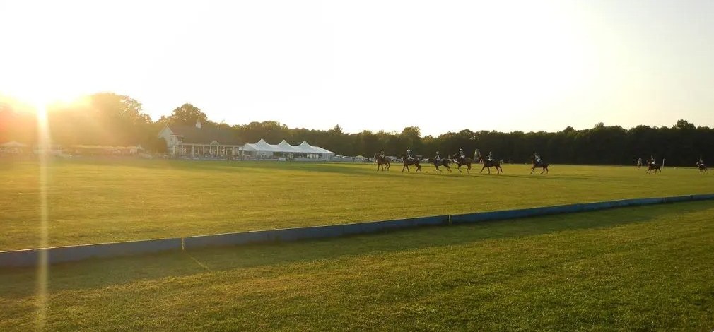
Whitney Field is eligible for the State and National Register of Historic Places. Polo was the reason the 2005 PUD was approved. The new plan keeps 5.1 acres as a paddock and event lawn. The President of the U.S. Polo Association says that "will simply not work for outdoor polo."
The facts & sources
- The applicant's own environmental form lists "Eligible property: Whitney Field." EAF Part 1, E.3.e
- The applicant says about 10 acres were used for polo and that 5.1 will remain. A regulation field with safety margins needs 12.4 acres (300 × 160 yards of play).
- The remaining 5.1 acres become grazing for up to 8 of the developer's horses, plus outdoor event space. Application, p. 3–4
- Leighton Jordan, President of the USPA and founder of Saratoga Polo, wrote: "In my opinion the proposed concept will simply not work for outdoor polo on a regulation field." (letter to the Planning Board, Oct 12, 2026)
07
Years of town growth in a single project
Greenfield grew by about 230 people from 2010 to 2020. This one project would add roughly 350–440 residents, more than 15 years of the town's population growth at once. It would also enlarge the town's entire housing stock by 5%, adding demand on schools, roads and services.
The facts & sources
- Population: 7,775 in 2010 and 8,004 in 2020 (U.S. Census), and about 8,039 today (ACS 2020–24).
- Housing: about 3,571 homes and 3,276 households in Greenfield today (ACS 2020–24). The town added about 515 households from 2000 to 2024, roughly 21 a year. 184 units equals about 9 years of that pace.
- Residents: at the town's average of 2.4 people per household, 184 units means about 440 people. Smaller units point to about 350 or more.
- Schools: the applicant's own estimate is 27 public-school children in the Saratoga Springs district. Socio-economic study, p. 7
- The 2005 approval assumed mostly older buyers in seasonal, fractional units. This plan is 184 year-round rentals.
08
A private complex with no public amenities
The pool, gym, pickleball courts, dog park, trails and stables are all for tenants only. The 220-seat event hall is a rental venue for weddings and corporate events. The only new pipes are the ones the project needs for itself.
The facts & sources
- The proposed law defines the amenities as "for the benefit of the residential users of the Property." Proposed amendments, definitions
- The stables "will not be open to lease to the public," and "there will be no public streets on the Property." Application
- The event space is offered "to residents… and outside users to host celebrations, banquets and other similar functions," with its own kitchen and bar.
- The applicant mentions hosting charity events and exhibition polo, but these are intentions. Nothing in the proposed law requires them.
- Some homes along the pipe route could connect to the new water and sewer lines at their own expense. Those lines exist only because the project needs them.
09
Event noise and hundreds of new lights at night
A 220-seat event hall with a bar will host recurring private events, but the developer has given no schedule for how often or how late. 37 buildings, private roads and 503+ parking spaces will need outdoor lighting, which permanently changes the night sky over the surrounding area.
The facts & sources
- The venue is for "weddings, corporate retreats and private functions," and the paddock lawn is for "larger outdoor events which may want outdoor seating." Socio-economic study, Application
- The environmental form leaves operating hours blank and describes construction noise only. It says nothing about event noise.
- On lighting, the form's entire answer is "All lighting will be dark sky compliant." It gives no fixture locations, heights, aiming or count, even though the form asks for them. EAF Part 1, D.2.m–n
- The applicant's attorney has told the Board that tenants will be on notice that the community holds recurring events, and must accept the noise as part of their leases. The surrounding neighbors signed no such lease.
10
Water from a lake already past its limit
The project would draw up to 50,000 gallons a day from Saratoga Springs' Loughberry Lake. The City already uses more water on an average day than its own 2025 engineering study says the lake can safely supply.
The facts & sources
- The City produced about 4.55 million gallons a day on average in 2025 (City of Saratoga Springs 2025 Water Quality Report).
- The March 2025 Barton & Loguidice study found the lake's safe yield has fallen to about 4.3 million gallons a day, down 22% from 5.5.
- The applicant's certified environmental form gives the project's demand as 50,000 gallons a day. EAF Part 1, D.2.c
- The City also loses an estimated 20–25% of its treated water to leaks.
11
Wetlands are badly understated
The application reports 2.57 acres of wetland. The Town's own 2005 study found 6.28 acres. Federal mapping of the Putnam Brook corridor shows a forested wetland complex of about 20.8 acres, which includes a state Class I wetland, the highest protection category.
The facts & sources
- The 2005 delineation by Copeland Environmental identified DEC Class I wetland S-48, which carries a 100-foot protected buffer.
- The National Wetlands Inventory maps the Putnam Brook forested wetland (PFO1E) at about 20.83 acres, plus stream-connected wetland segments near the pipe routes.
- The site sits over a principal aquifer next to a DEC-classified trout stream.
- The land-cover table in the environmental form adds up to about 37.7 acres, not 42.7, leaving about 5 acres unaccounted for. EAF Part 1, E.1.b
12
If the finances fail, Greenfield is left with the problem
The rents the plan depends on are 23–28% above downtown Saratoga Springs, and on the applicant's own numbers the project doesn't cover its likely mortgage. If renters don't come, the likely result is cut-rate operation, disrepair or a sale to the lowest bidder. The rezoning stays with the land either way.
The facts & sources
- The project costs about $79 million, with proposed rents of $2,475–$4,500 a month. Qualifying for them takes household incomes of about $99,000–$180,000. Socio-economic study
- The expected return on cost is about 4.4–5.3%, against the 7–8% developers typically need.
- Rental income would cover the debt payments only 0.72–0.90 times over. Lenders usually require at least 1.25.
- The site has seen this before. The former owner told the Board that after the earlier project's financing collapsed, the property suffered "neglect, deterioration, and the clubhouse becoming a squatting location."